

Rogue Gorge 50K
October 17, 2026
50K
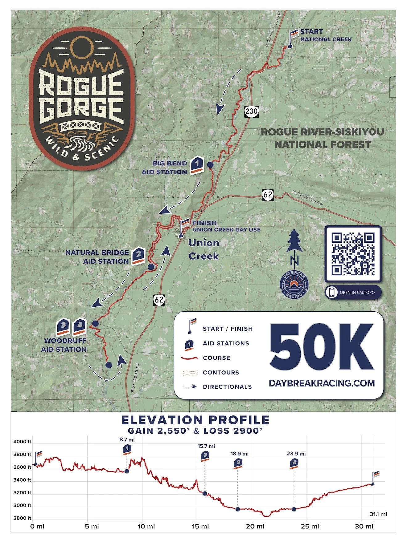
The Rogue Gorge 50K is a super beautiful, fast-paced point-to-point course, and is 99% singletrack trail! The route travels along the rim of the Upper Rogue Wild & Scenic River for the entire route, involving 31.1 miles with 2550 ft. of ascent and 2900 ft. of descent. There are 4 aid stations along the course.
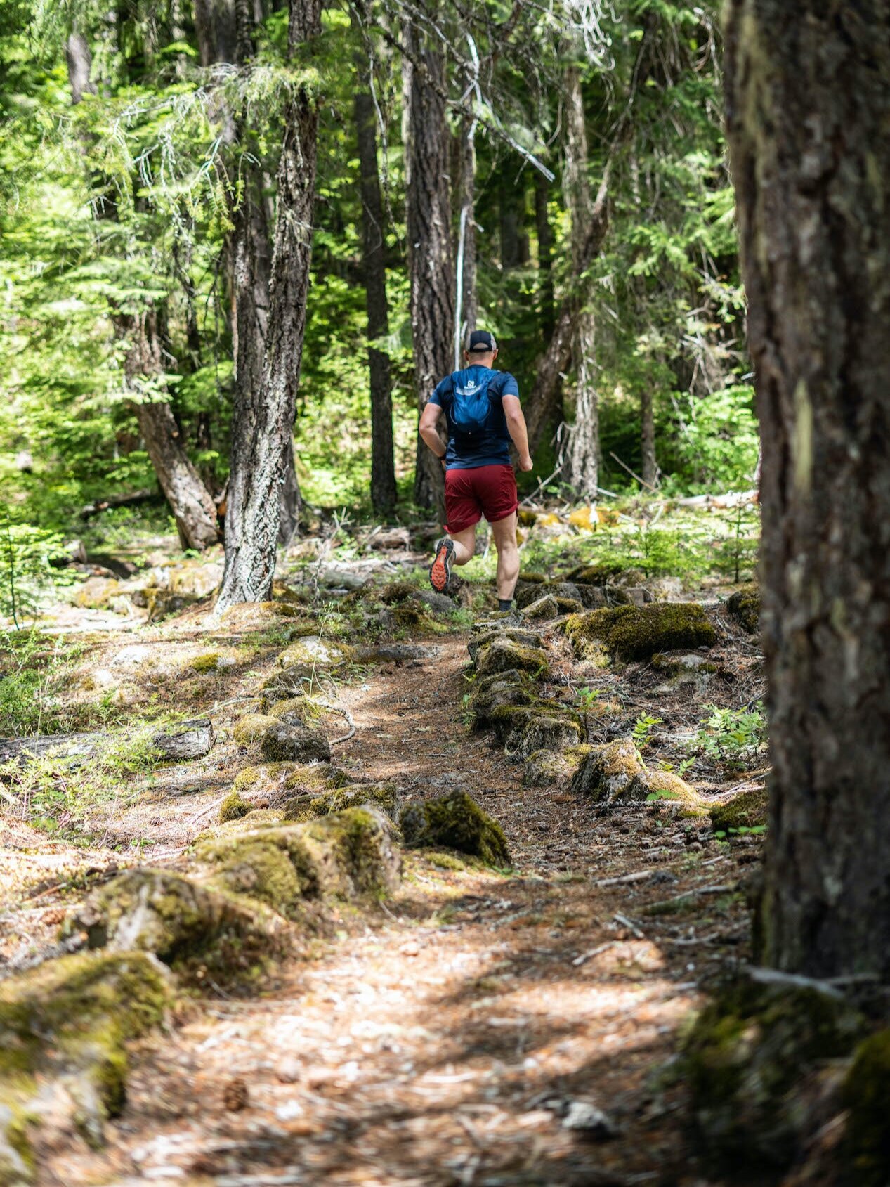
The first half of the course is composed of mostly gently rolling, runnable dirt singletrack, while the second half is less hilly and faster but includes more technical lava rock sections. The trail surface is characterized by an intermittent assortment of smooth dirt trail, technical basalt lava rock and some rooty dirt trails— the technical sections will test your quick footwork and demand your focus but are super fun :)
Race Day Timeline
RACE DAY: Saturday, October 17, 2026
CHECK-IN: 6:00-7:45AM
SHUTTLE BUS DEPARTS: 7:50AM @ Union Creek Wayside
START TIME: 8:30AM @ National Creek
FINISH: Union Creek Day Use Picnic Shelter
Shuttle to Start
ALL runners are required to ride the shuttle buses from the Union Creek staging area up to the start line. No drop offs or crew/spectators are allowed at the start line. The shuttle trip is approximately 15-20 minutes.
Course Map & Profile
Click on the course map image to open/save a high resolution copy.
INTERACTIVE MAP: Click HERE for an interactive course map in Caltopo.
GPX DATA: Click HERE for a .gpx data file of the course.
ELEVATION CHANGE: The course has 2550’ of ascent and 2900’ of descent.
Aid Stations
The 50K includes four aid stations staffed with enthusiastic, experienced volunteers, plus medical personnel present with a full compliment of emergency response and first aid equipment.
Hydration & Nutrition
All aid stations will be well stocked with Neversecond C30 energy gels and C30 hydration drink (30g of carbs plus electrolytes!), water, soda, PB&J sandwiches, cookies, various fresh fruit options, potato chips, gummi snacks, trail mix and a variety of other ultra fare and basic first aid supplies.
All Daybreak races are CUPLESS
Be sure to bring your own reusable drinking vessel/cup for liquids such as soda at aid stations.
| Aid Station | Total Distance (mi) | Segment (mi) | Drop Bag | Restroom | Crew Access |
|---|---|---|---|---|---|
| Start | 0 | 8.7 | -- | Yes | -- |
| 1 - Big Bend | 8.7 | 7.0 | Yes | Yes | Yes |
| 2 - Natural Bridge | 15.7 | 3.2 | No | No | No |
| 3 - Woodruff Bridge | 18.9 | 5.0 | Yes | Yes | Yes |
| 4 - Woodruff Bridge (2) | 23.9 | 7.2 | Yes | Yes | Yes |
| Finish | 31.1 | -- | -- | Yes | Yes |

Crew Access
Crew and spectators are welcome at Big Bend and Woodruff Bridge. Please be sure to park respectfully in day use parking areas or on available roadside areas that do not block emergency vehicle egress, general vehicle access or the race course.
PLEASE PRINT THESE DIRECTIONS IN ADVANCE, as there is no internet in the area and we do not have the capacity to field ongoing questions from crew.
Turn by turn directions from Union Creek to Big Bend Aid Station (#1):
Go NORTH on Hwy 62 for 1.2 miles
Continue straight to merge onto Hwy 230.
Continue NORTH on Hwy 230 for 0.9 miles.
Turn LEFT onto Forest Road 6510 (Hersberger Road)
Follow Road 6510 for 0.8 miles to pass the Big Bend Trailhead and park in the large open gravel area on the left, across the road from the aid station. Walk down 100 yards to the aid station.
TOTAL DRIVE TIME ~10 minutes
Turn by turn directions from Union Creek to Woodruff Bridge Aid Station (#3 & 4):
Go SOUTH on Hwy 62 for 4.7 miles
Turn RIGHT onto Abbot Creek Road / Forest Road 68 for 1.8 miles
Park at Woodruff Bridge Day Use or along Forest Road 68 road shoulder. Runners cross the road here! Use caution and do not block the race course.
TOTAL DRIVE TIME ~10 minutes
Drop Bags
Drop bags will be available at Big Bend Aid Station 1 and Woodruff Aid Station 3/4.
SIZE: One drop bag per aid station per runner is allowed. Smaller than a 20L daypack, water resistant and made of durable material. Bags that are too large or heavy will not be accepted or delivered to the aid station.
LABEL: Arrive to the race with a pre-made label adhered/attached to your drop bag that includes your first name, last name and bib number in large bold permanent writing. (By race week, your bib # is next to your name on the Ultrasignup participant)
RETURN: Please consider that drop bags will not be returned back to your race staging area until the aid station shuts down after race sweepers arrive. Have your crew grab your drop bags from the aid station if possible.
CONTENTS: Do not store valuables in drop bags! The race is not responsible for missing, damaged, lost or stolen drop bags or contents.
FORGOTTEN BAGS: Please note we do not ship or deliver forgotten drop bags. You can arrange to pick up forgotten drop bags from us if we have them.
Course Detail
Start to Aid Station 1 (Big Bend): Runners start at a large open area inside the fork of two forest roads near National Creek. From the start, runners follow the paved National Creek Road for .3 miles, crossing a road bridge over the Rogue River, then make a hard LEFT onto the Upper Rogue River Trail (URRT). The trail undulates along the river for 1.8 miles, then crosses Hwy 230 — stop, look both ways, and cautiously cross the highway only when safe to do so, as vehicle traffic DOES NOT STOP. After the highway crossing, the trail rolls down for .7 miles to a stream crossing of Foster Creek. Ford this shallow stream and veer RIGHT to regain the trail. The next few miles of trail are the most remote and primitve of the entire course, with a continuous mix of rolling, punchy small climbs and descents mixed with flat, speedy and cruisy sections. This segment is a very old trail, evidenced by the many axe-carved trail blazes on the trees (a trail marking practice that stopped in the 1950’s). The river is lazy and quiet on much of this segment, but the dramatic pumice cliffs, lush meadows and many colossal 7-8’ wide Douglas firs never cease to inspire. Less than 2 miles from the first aid station, the river picks up steam with some lovely rapids and a fast, flat arrival at Big Bend Aid Station. Crew and Drop Bags available.
Aid Station 1 (Big Bend) to Aid Station 2 (Natural Bridge): Departing Big Bend Aid Station on a dirt skid road, turn LEFT onto a short connector trail, then veer LEFT again onto a major gravel forest road for 200 yards, then turn RIGHT to get back on the Upper Rogue River Trail. The course undulates over the next 6 miles through gullies, and a mix of punchy climbs and descents, often climbing high above the river overlooking the Rogue Gorge canyon, while also dropping down right along the raging river’s edge at other times. Eventually the trail fords the very shallow and tranquil Flat Creek, then a mile later, veer RIGHT at a trail junction to stay on the URRT. A mile later, the trail reaches the spectacular Natural Bridge area, where the entire river gets swallowed into an underground lava tube and springs back up to the surface a hundred yards downstream, where you’ll reach Natural Bridge Aid Station. No crew access or drop bags.
Aid Station 2 (Natural Bridge) to Aid Station 3 (Woodruff Bridge): From Natural Bridge Aid Station, the course crosses the gorgeous arched footbridge over the river then turns RIGHT and continues downstream along the URRT for a bit over 3 miles to Woodruff Bridge Day Use Area, crossing a somewhat busy paved forest road (use caution and look both ways before crossing!) to reach the aid station. You’ll find the river’s character shifts constantly from loud and raging one minute, then silent and gently flowing the next. Overall this is the fastest segment of course, as it is mostly flat and non-technical dirt single track.
Aid Station 3 (Woodruff Bridge) to Aid Station 4 (Woodruff Bridge): Past Woodruff, runners continue downstream along the URRT through more ancient old growth along the river. Leaving the aid station, the fall foliage along the river is insanely vibrant through this area in particular. The course then enters a more technical basalt lava section here, especially while passing the beautiful Takelma Gorge, a deep, narrow chasm where the entire river is heaved around a tight 90 degree turn, where huge old logs are tossed up on the riverbank like toothpicks during the highest flows of spring melt out. At the downstream end of Takelma Gorge at 2.5 miles from Woodruff Aid Station #3, runners reach the major 50K TURNAROUND point on the course. Runners return upstream, savoring this serenely forested section of sugar pine, ponderosa pine and Douglas fir forest. Look for the sugar pine’s gigantic cones lying around along the trail, some reaching 1.5 feet long…the biggest of any conifer in the world! Returning upstream, runners travel back along the trail from a different angle and perspective, enabling views they may have missed on the way out of Takelma Gorge on the way back up to Woodruff Bridge Aid Station. Crews and Drop Bags available.
Aid Station 4 (Woodruff Bridge) to Finish: Departing Woodruff Bridge Aid Station, runners travel the 3+ miles back up near Natural Bridge, then turn RIGHT onto a brief paved section of the Rogue Gorge Trail, through Natural Bridge Day Use Area (vault toilets available here is needed) then veers LEFT as the trail then turns back to dirt singletrack, skirting along the river next to Natural Bridge campground. Runners continue upstream, skirting around several Natural Bridge campground campsites on the Rogue Gorge Trail for a bit over a mile and will veer RIGHT past the a big silver wooden footbridge (do not cross this footbridge). Runners continue upstream past the Natural Bridge campground on the Rogue Gorge Trail for a bit over a mile and will veer to the right past a cool looking big silver footbridge. Stay right here and do not cross the footbridge. The trail follows the river for another 1.5 miles, then enters the Union Creek Campground. At the Union Creek footbridge, the course veers LEFT over the footbridge, then veers LEFT again to stay on the Rogue Gorge Trail and travels upstream between the river and the Union Creek Campground, then past several forest cabins for a mile or so, then climbs briefly to reach the Rogue Gorge Day Use and Interpretive Site. The Rogue Gorge itself is truly magnificient, where the entire river is squeezed into a deep rocky chasm of boiling, churning and raging water below seems surreal. The course makes a hard RIGHT turn on the paved trail, crosses through the Rogue Gorge Day Use parking area to gain a short segment of connector trail, then veers RIGHT onto a gravel road, then a quick LEFT to enter the Union Creek Picnic Area for the glorious finish!
Pacers
The event permit does not allow pacers.
Weather
Check the latest local weather here.
Cancellations
See the Daybreak Racing Cancellation Policy.
This event is located on the Rogue River-Siskiyou National Forest. In accordance with Federal law and U.S. Department of Agriculture policy, this institution is prohibited from discriminating on the basis of race, color, national origin, sex, age or disability. USDA is an equal opportunity provider and employer.