

The Big Alta 100K
March 20, 2027
100K
Welcome to The Big Alta 100K, a truly spectacular point-to-point trail race immediately north of San Francisco. We originally dubbed this course concept “Trans-Marin” a few years ago because of its epic traverse of the Marin County region. The course packs a laundry list of “greatest hits” scenic highlight locations into 62 miles, including Fort Baker, the Golden Gate Bridge, Marin Headlands, Stinson Beach, Mt. Tamalpais east peak, Lagunitas Lake, Pine Mountain, Loma Alta, Big Rock Ridge and more!
The course is as challenging as it is scenic, amassing 12,750’ of vertical gain (same loss) on a mix of singletrack trail and California carpet fire roads, and great crew access to boot. We consider this course and the extensive permit approvals required to host this race as one of our greatest accomplishments… We can’t wait to share it with you!
Bib Pickup
ALL 100K runners must pick up their bibs BEFORE race day. NO RACE MORNING BIB PICKUP is available. Here are the bib pickup options:
Thursday, March 18, 2PM-6PM at SFRC Mill Valley or
Friday, March 19, 9AM-4:30PM at Marinwood Community Center staging area.
Pre-arranging friend/family pickup for you is allowed with a note or photo of your ID from you shown.
Racer Meeting
Friday, March 19, 4:00PM-4:30PM @ Marinwood Park finish line area. Plan to attend this meeting for participants and crews for a final bib pickup opportunity, drop off drop bags, receive a welcome message from Daybreak and Freetrail, review final race day safety items and any course updates/changes.
Race Day Schedule
Saturday, March 20, 2027
Shuttle Bus Pick Up: Must have prepaid for shuttle pass. Load up at Marinwood Community Center at 4:45AM, buses depart by 5:00AM. Shuttle Bus is OPTIONAL. Runners may be dropped off at Start Line at Fort Baker by crew/supporters AFTER 5:30AM. Warm ups may be left on the start line tarp area, which are then taken to the finish line drop bag return area.
Start Line Drop Off: 5:30AM at Fort Baker.
Runners may be dropped off by car at Fort Baker for the start, AFTER 5:30AM. Do not arrive before 5:30AM due to National Park Service restrictions. Overnight parking is also NOT allowed unless you’re lodging at Cavallo Point nearby.
Race Start: 6:00AM at Fort Baker (mass start, no waves, no announcements)
Awards Ceremony: 7:00PM
Finish Line Cut-Off: 11:00PM (17 hours). See chart below for on-course cutoffs.
Course Map
CLICK “Open in Caltopo” in the map to open in a new tab.
INTERACTIVE MAP: Click HERE for an interactive course map where you can change layers, zoom in and out, view elevation profile, etc.
GPX DATA: Click HERE for a .gpx data file of the course with elevation data included. File version: 1-2026
Mandatory Equipment
The 100K course .gpx data file uploaded onto your preferred navigation device (gps watch or smartphone nav app such as Gaia, Strava, Caltopo, etc.) is required on race day and during the race. We require this to ensure course markings are not a runner’s sole reference for navigating the race course, as this is a heavily used region and course markings can be removed or tampered with.
Elevation Change
Approximately 12,750' of ascent and 12,700' of descent.
Aid Stations
There are 9 aid stations on the course, all staffed with experienced, enthusiastic volunteers plus professional medical personnel.
All Daybreak races are CUPLESS.
Be sure to bring your own cup for liquids at aid stations (or use your hydration supplies, such as bottles, bladder, etc.).
Hydration and nutrition options included at aid stations: Neversecond C30 gels (except aid 1 and 2, see note below) and C30 sports drink (30g of carb and 200mg sodium per serving for gels and drink), water, soda, bananas, oranges, chips, PB&J sandwiches, and more. Later aid stations will include warm, savory options.
PLEASE NOTE: Event Permits within GGNRA do not allow for Rodeo Beach and Muir Beach Aid Stations to distribute gels. Runners are allowed to carry their own gels through these aid station locations. Neversecond C30 gels will be provided to all runners beginning at Cardiac Hill Aid Station (#3).
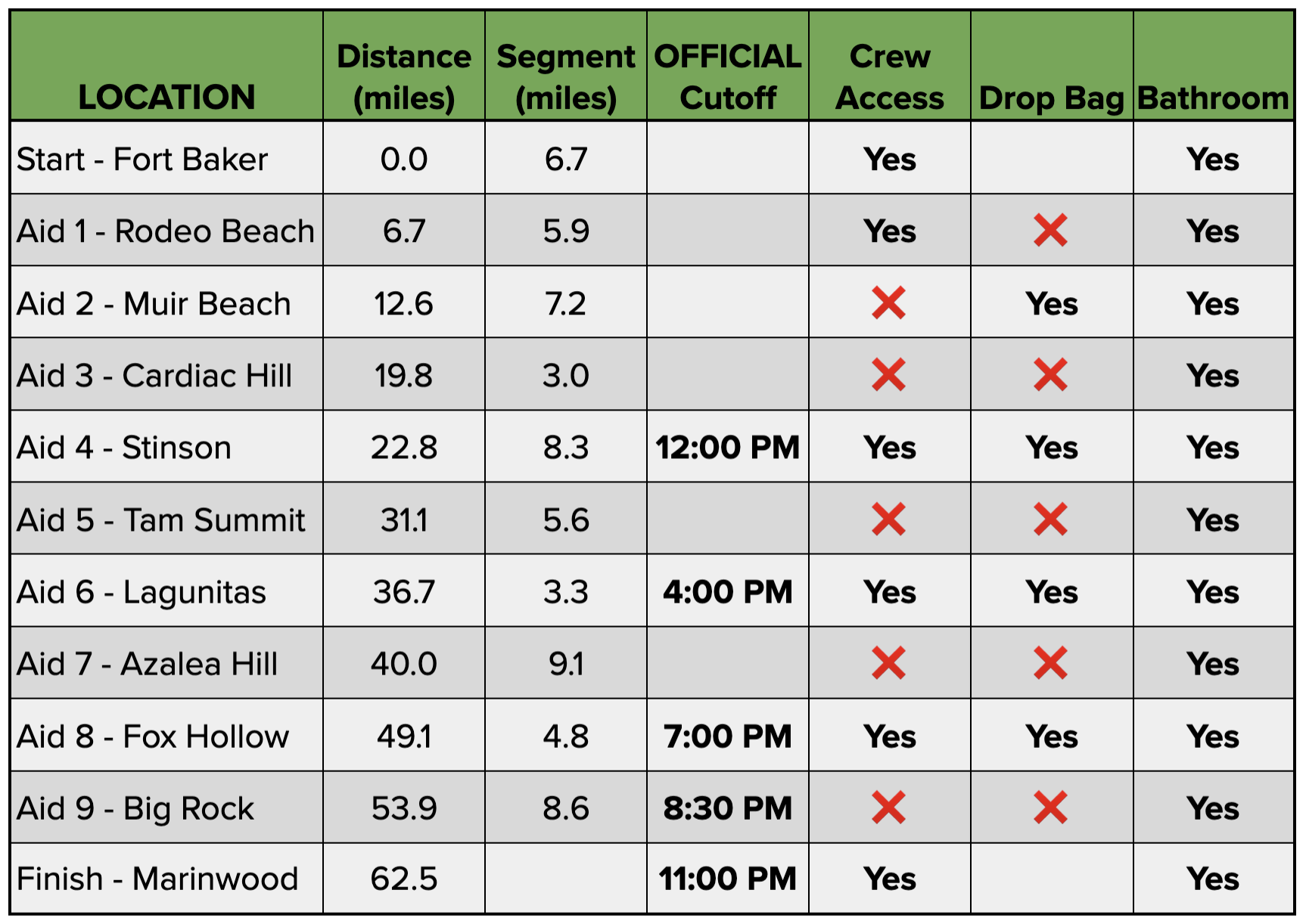
Crew & Spectators
Crew are allowed at the following locations:
Fort Baker Start Line Area
Rodeo Beach Aid Station #1
Stinson Aid Station #4
Lagunitas Aid Station #6
Fox Hollow Aid Station #8
Marinwood Community Center Finish Line Area
There is no crew/spectator access allowed at any other aid stations or on course due to permit restrictions and parking limitations.
VEHICLES: ONE passenger vehicle per participant is allowed for crew. No RVs, trailers, busses, etc., allowed or any vehicle larger than a standard parking lot stall in size.
Download, save, and study the Crew Guide HERE:
Drop Bags
Drop bags will be available at Aid Station #2, #4, #6 & #8.
PLACEMENT: All drop bags must be placed on the labeled tarps at Marinwood Community Center on Friday by 5PM.

LABEL: Drop bags MUST BE labeled with your name, race, bib number and aid station name in permanent marker before 5PM Friday of race weekend.
SIZE: Drop bag size must be smaller than a 20L day bag (shoe box size), made of durable, water-resistant material and less than 5lbs. Bags that are too large or heavy will not be accepted and will not go the requested aid station.
RETURN: Drop bags will be brought back to the Marinwood Community Center finish line area on race day AFTER each aid station closes. Drop bags will be available for pick up until Sunday at 1:30PM of race weekend.
CONTENTS: Do not store valuables in drop bags! This includes car keys, ID, phones, bank cards, anything expensive, etc. The race is not responsible for missing, damaged, lost or stolen drop bags or contents.
FORGOTTEN BAGS: Please note we do not ship or deliver forgotten drop bags. You can arrange to pick up forgotten drop bags from us if we have them.
Poles
Trekking poles are allowed.
Pacers
No pacers allowed.
Inclement Weather Equipment Policy
If we have wet/inclement weather on race day, we will have a gear requirement for all runners that will help keep them prepared for confronting all types of conditions and in the event of a health/safety incident, allow a runner to wait for rescue and extraction. If implemented, the gear requirement will be in place for the duration of the race from start to finish. Gear checks shall be in place at aid stations. Required gear will include: a running pack, waterproof rain jacket, smartphone with course info and means of contact by race staff, emergency blanket, whistle, 400 calories of nutrition, 1 liter capacity of fluids, hat or bandana, ID.
Course Detail
Overall, the course is very runnable, but there are some major climbs that will ensure much of the fun being had is the Type 2 variety :) Fortunately, this is Marin County, with its globally-renown natural beauty and scenery providing ample distraction, as well as opportunity for reflection and gratitude. Course surfaces are predominantly a mix of dirt fire roads and single track trail, with some gravel fire roads and a dash of pavement at the beginning and end of the course.
Start (Fort Baker) to Aid Station 1 (Rodeo Beach):
6.7 miles. Start at Fort Baker in the Golden Gate National Recreation Area, departing almost immediately under the Golden Gate Bridge on the paved Fort Baker Bay Trail, climbing up and crossing Conzelman Rd to reach SCA Trail at 1.0 mile and follows SCA for 2 miles, then veer LEFT onto Rodeo Valley Trail for a 2 mile descent. The course veers LEFT briefly onto Bobcat trail, then LEFT again onto Miwok Trail for 0.5 mile, then crosses Bunker Road and veers RIGHT onto Lagoon Trail that parallels the road for 0.75 mile to Rodeo Beach for Aid Station 1. Crew Access available.
Aid Station 1 (Rodeo Beach) to Aid Station 2 (Muir Beach):
5.9 miles. Runners depart Rodeo Beach on Coastal Trail for 1.7 miles of steady climbing, gaining the Hill 88/Wolf Ridge ridgeline, then turns sharply LEFT to stay on Coastal Trail at its junction with Wolf Ridge Trail, descending for a bit over a mile to cross Tennessee Valley trail. The course continues straight on Coastal Trail for 3 miles, climbing and descending through the iconic Pirates Cove area before a 0.75 mile descent into Muir Beach for Aid Station 2. Drop Bags available.
Aid Station 2 (Muir Beach) to Aid Station 3 (Cardiac Hill):
7.2 miles. Leaving Muir Beach, the course follows Pacific Way road for 0.25 mile to Hwy 1. Runners cross the roadway only when safe to do so and with permission from course marshal onsite, then veer RIGHT onto Dias Ridge Trail for 2.7 scenic miles. The course then turns LEFT onto Miwok Trail for 1.6 miles before veering RIGHT onto Redwood Creek Trail briefly before reaching Muir Woods Rd. Runners STOP at the road crossing and wait for permission to cross. Leaving Muir Woods Road onto Deer Park Fire Rd for 0.5 mile before gaining the famous Dipsea Trail for 1.75 miles to reach Cardiac Hill for Aid Station 3.
Aid Station 3 (Cardiac Hill) to Aid Station 4 (Stinson):
3.0 miles. Departing Cardiac Hill, runners get a cruising descent for 2.9 miles on the Dipsea Trail to Highway 1, then follow the narrow highway shoulder for 50 meters, turning right onto Belvedere Ave in front of the Stinson Beach Fire Station to reach the Stinson Beach Community Center for Aid Station 4. Crew Access and Drop Bags available.
Aid Station 4 (Stinson) to Aid Station 5 (Tam Summit):
8.3 miles. This section is the crux of the race and the most challenging segment, with 3000’ of climbing over 8.1 miles. Runners depart Stinson aid station on Belvedere Ave heading east to reach the Matt Davis Trail for a 4 mile climb, gaining 1000’ in the first 1.25 forested miles before breaking out into grassy meadows, offering spectacular views. Runners reach Pantoll Road, then Runners STOP at the road crossing and wait for permission from traffic control to cross. After the road crossing, running continue briefly on Matt Davis Trail, then veer LEFT very briefly onto Old Stage Rd, then turn LEFT onto Old Mine Trail, offering more spectacular ocean and Bay Area views for 1.0 mile, then veers RIGHT onto Mountain Theater fire road to reach the historic Mountain Theater. The course continues across the top of Mountain Theater on Rock Springs Trail for 1.5 miles, then veers LEFT onto Old Railroad Grade fire road for 1.7 miles to reach Tam Summit for Aid Station 5.
Aid Station 5 (Tam Summit) to Aid Station 6 (Lagunitas):
5.6 miles. Departing Tam aid station, runners veer RIGHT onto Verna Dunshee Trail for a stunning 360* half mile loop trip around the summit of Mt. Tamalpais, the highest point in Marin County, then turn RIGHT on the wood deck path past the Visitor Center, down a few steps then turns LEFT onto a little used tie trail for 200 meters to connect onto Eldridge Grade fire road for a 3.5 mile sweeping descent into the Mt. Tam Watershed. Leaving Eldridge Grade, the course veers LEFT onto Lakeview fire road for 1.25 miles to Lagunitas Lake for Lagunitas Aid Station 6. Crew Access and Drop Bags.
Aid Station 6 (Lagunitas) to Aid Station 7 (Azalea Hill):
3.3 miles. Leaving Lagunitas Aid Station, runners follow the serene Shadyside Trail along the shoreline of Bon Tempe Lake, cross the Bon Tempe Dam Road to Bon Tempe Trailhead. The course turns LEFT on Bullfrog fire road for 0.25 miles, then turns LEFT over a footbridge onto Azalea Hill Trail for 1 mile to Azalea Hill Aid Station 7.
Aid Station 7 (Azalea Hill) to Aid Station 8 (Fox Hollow):
9.1 miles. After leaving Azalea Hill Aid Station, runners cross Fairfax Bolinas Road (look both wasy before crossing), then follow Pine Mountain fire road for a somewhat technical rocky and rolling 1.7 miles. Continuing straight, the route follows the relatively flat, gently rolling San Geronimo fire road for 1.5 miles before turning RIGHT onto White Hill fire road. The course follows the rolling White Hill fire road for 2.2 miles, then descends the Porcupine Trail, then White Hill Trail for over a mile before passing underneath Sir Francis Drake Blvd, then merging onto Old Railroad Grade fire road. Runners stick to Old Railroad Grade for a flat and smooth 1.9 miles, then the short Fox Hollow Trail for .25 miles to reach Fox Hollow Aid Station. Crew Access and Drop Bags available.
Aid Station 8 (Fox Hollow) to Aid Station 9 (Big Rock):
4.8 miles. Runners depart Fox Hollow Aid Station up the gravel Glen fire road then Smith Ridge Fire Road for a stubborn, steady grade 2 mile climb, pass through a cattle gate, then veer RIGHT onto the dirt Loma Alta fire road as the course continues to climb, cresting the broad, bald summit of Loma Alta. Savor the epic 360° summit views, followed by a steady 2.1 mile ripping descent down to Big Rock Aid Station at mile 53.3.
Aid Station 9 (Big Rock) to Finish (Marinwood Community Center):
8.6 miles. Leaving Big Rock Aid Station, the course uses a pedestrian tunnel under Lucas Valley Road to connect onto the Big Rock Trail for a stout 3 mile, 1500’ ascent to gain the ridgeline of Big Rock Ridge, the second highest point in all of Marin County. The ridgeline offers 360° views of the entire San Francisco Bay Area and beyond. From the Big Rock Ridge summit near the radio towers, the course follows Big Rock Ridge fire road on a gradual, rolling descent for 2 miles to the junction with Queenstone Fire Rd. Runners will veer RIGHT at this junction onto Queenstone fire road, where the course drops along a big 2 mile descent, with sweeping views of Marinwood and the Lucas Valley below. At the bottom of Queenstone fire road, runners pass a fire gate into the paved Marinwood neighborhood street of Queenstone Drive, cross Miller Creek Road at the cross walk, then turn RIGHT onto the sidewalk of Miller Creek Road for the final gradual half mile descent to Marinwood Community Park for the finish!
Cancellations
See the Daybreak Racing Cancellation Policy.