

The Big Alta 28K
March 21, 2027
28K
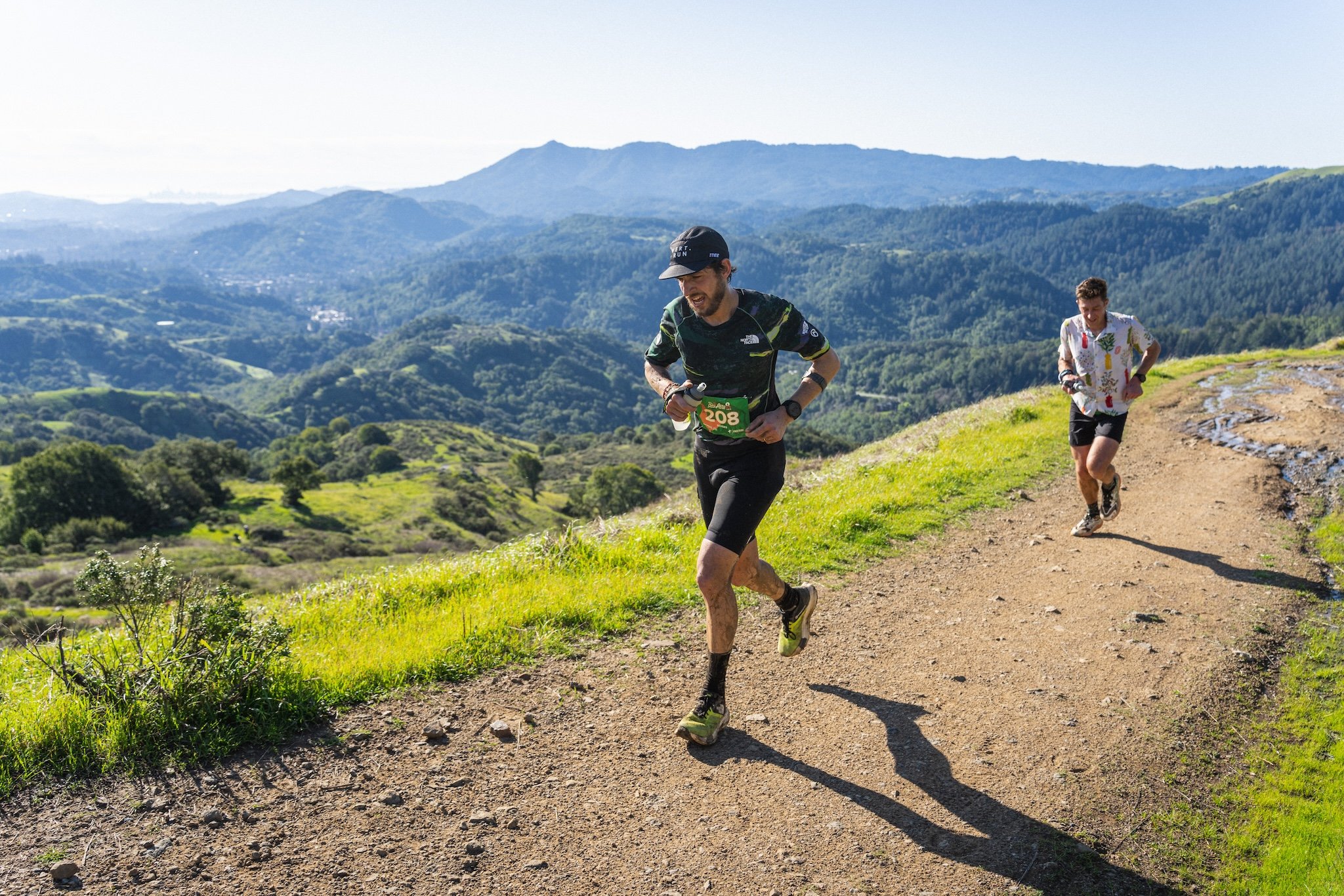
The Big Alta 28K course features a spectacular single-loop race route, with extensive scenic views along some of the highest points in all of Marin County. The course is composed of a rugged mix of dirt double track fire roads and single track trails along exposed ridgelines, across hilly open grassland meadows and oak woodlands. We can’t wait to share this super fun (and tough) shred with all the runners!

Race Day Schedule
Sunday, March 21, 2027
Bib Pickup: 6:45AM-7:50AM
Race Start: 8:00AM (single mass start, no waves)
Awards Ceremony: 12:00PM
Finish Line Cut-Off: 1:30PM (5.5 hours)
Course Map
INTERACTIVE MAP: Click HERE for an interactive course map where you can change layers, zoom in and out, view elevation profile, etc.
GPX DATA: Click HERE for a .gpx data file of the course with elevation data included.
Elevation Change
Approximately 3,900' of ascent and 3,900' of descent.
Aid Station
There is one aid station on the course about halfway through the race. It will be staffed with experienced, enthusiastic volunteers plus professional medical personnel to help ensure every runners has the best, safest experience possible.
All Daybreak races are CUPLESS. Be sure to bring your own cup for liquids at aid stations (or use your hydration supplies, such as bottles, bladder, etc.).
Hydration and fuel options included at all aid stations: Neversecond gels and hydration drink, water, soda, bananas, oranges, potato chips, PB&J sandwiches, and more.
| Aid Station | Total Miles | Segment (mi) | Toilet | Cutoff |
|---|---|---|---|---|
| Start - Marinwood Park | 0 | 8.8 | Yes | -- |
| #1 - Big Rock | 8.8 | 8.6 | Yes | 10:45AM |
| Finish - Marinwood Park | 17.4 | -- | Yes | 1:30PM |

Crew & Spectators
Crew and spectator access is allowed at Start/Finish area only. Spectators may hike anywhere along the course, but may not run the course with the race participants.
No crew/spectator access at Big Rock Aid Station due to extremely limited parking. Crew who park at Big Rock will disqualify their runner and be asked to leave. Please know that parking at Big Rock is a major violation of our permitting, which restricts emergency access and puts the future of the event in jeopardy. You’ve been warned :)
Drop Bags
Drop bags not available for the 28K.
Poles
Trekking poles are allowed.
Inclement Weather Equipment Policy
If we have wet/inclement weather on race day, we will have a gear requirement for all runners that will help keep them prepared for confronting all types of conditions and in case of a safety incident, allow a runner to wait for rescue and extraction. If implemented, the gear requirement will be in place for the duration of the race from start to finish. Required gear will include: a running pack, waterproof rain jacket, smartphone with course info and means of contact by race staff, emergency blanket, whistle, 400 calories of nutrition, 1 liter capacity of fluids, hat or bandana, ID.
Course Detail
Overall, the course is quite runnable, but there are a couple stout long climbs and many short grinder climbs that will ensure some of the fun being had is the Type 2 variety :) Fortunately, this is Marin County, with its world-renown scenic beauty providing ample distraction, as well as opportunity for reflection and camaraderie with the trail running community... after all, what brings people closer than the shared experience of suffering in a gorgeous place?! The course is predominantly a mix of dirt fire roads and single track trail, with some pavement at the beginning and end of the loop.
Start (Marinwood park) to Big Rock Aid Station:
8.8 miles. Runners depart the Start at Marinwood Community Park, cross Lucas Valley Road, then follow the brief paved Canyon Oak Drive along Miller Creek to enter Marin County Open Space. Runners follow the Old Lucas Valley Road, now a bike/pedestrian path, for 1/4 mile, then veer LEFT onto Water Tank Fire Rd for the first climb of the day. Gaining the Spring Hill ridge, runners get their first big views of the day as they veer RIGHT onto Spring Hill Fire Rd and climb long the ridgetop for a bit. After this nice warm up, the course makes a hard LEFT onto Patricia Fire Rd for a typically muddy but brief descent before a sharp RIGHT turn to stay on Patricia for short distance, then veer RIGHT onto Del Ganado Fire Road uphill to the junction with Terra Linda Fire Rd. Runner turn LEFT onto Terra Linda Fire Rd for almost half a mile, then turn RIGHT onto Luiz Ranch Fire Rd. The course continues westerly on Luiz Ranch Fire Rd. then veers LEFT on the 680 Trail, a super fun rolling trail with several quaint footbridges over babbling creeks, early season wildflower patches and oak groves. The 680 Trail makes a series of switchbacks as it climbs the eastern flank of Loma Alta, then ends onto Smith Ridge Fire Rd where runners veer RIGHT for a short distance, pass through a livestock gate, then veer RIGHT onto Loma Alta Fired Rd. The course continues a long steady climb, reaching the bald summit of Loma Alta at mile 6.7. Savor the epic 360° views as the course crests over the top of Loma Alta, followed by a steady 2.1 mile descent down to Big Rock Aid Station at mile 8.8. Replenish hydration and nutrition here at this halfway point.
Big Rock Aid Station to Finish (Marinwood Park):
8.6 miles. Leaving Big Rock Aid Station, the course uses a pedestrian tunnel under Lucas Valley Road to connect onto the Big Rock Trail for a stout 3 mile, 1500’ ascent to gain the ridgeline of Big Rock Ridge, the second highest point in all of Marin County. The ridgeline offers 360° views of the entire San Francisco Bay Area and beyond. From the Big Rock Ridge summit near the radio towers, the course follows Big Rock Ridge Fire Rd on a gradual, rolling descent for 2 miles to the junction with Queenstone Fire Rd at mile 14.6 on the course. Runners will veer RIGHT at this junction onto Queenstone Fire Rd, where the course drops along a big 2 mile descent, with sweeping views of Marinwood and the Lucas Valley below. At the bottom of Queenstone Fire Rd, runners pass the fire gate into the Marinwood neighborhood on Queenstone Drive, cross Mill Creek Road at the cross walk, then turn RIGHT onto the sidewalk of Mill Creek Road for the final gradual half mile descent back to Marinwood Community Park for the finish!
Cancellations
See the Daybreak Racing Cancellation Policy.