

Wy'east Trailfest 28K
August 15, 2026
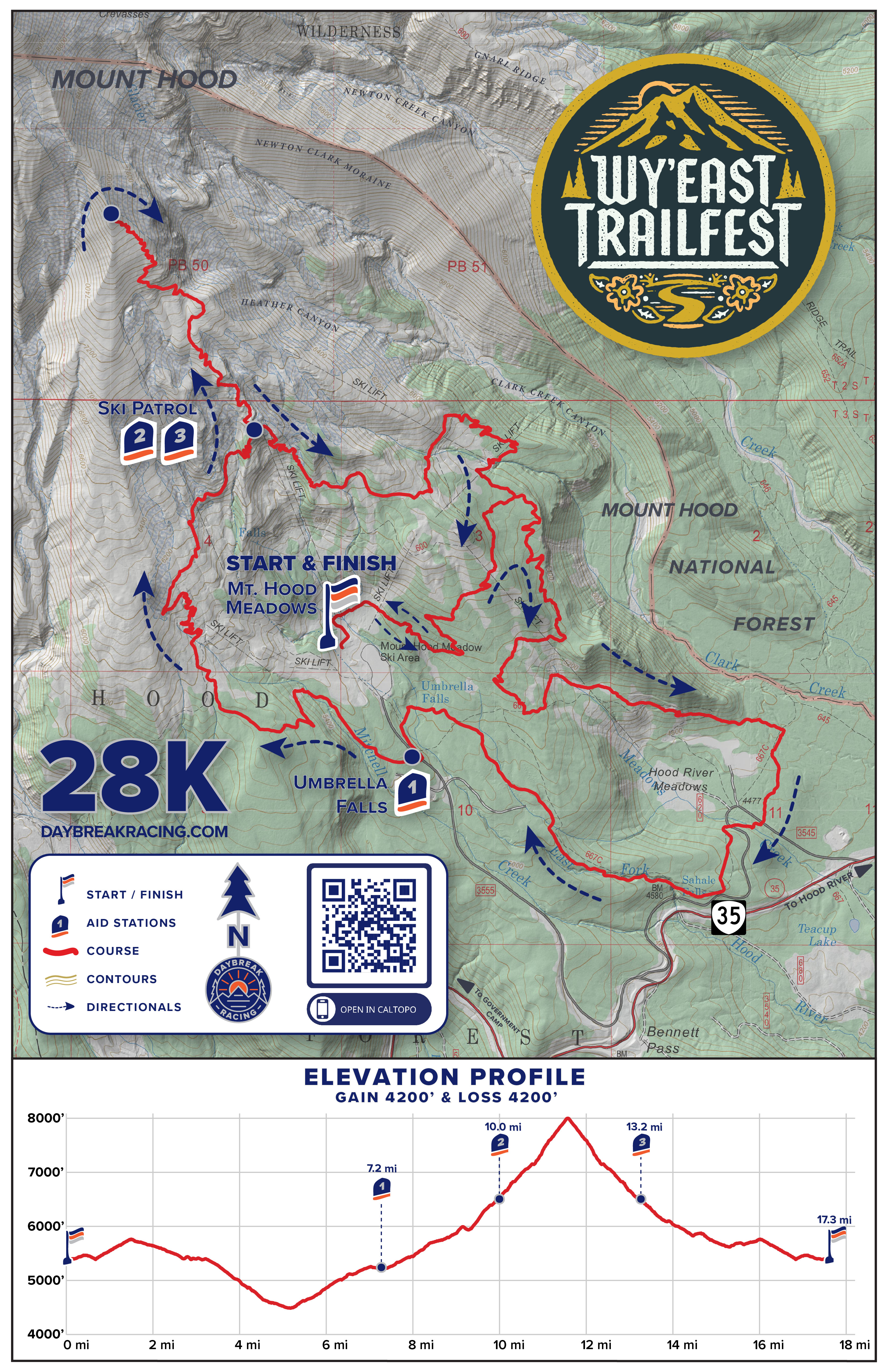
28K to the rooftop of Oregon
17.1 miles / 4,300’ of gain / 95% singletrack
The 28K course offers a world-class lollipop loop route on volcanic alpine ridgelines up high, and deep forests, wildflower meadows and waterfalls down low. This is a very challenging mountain trail race, starting and finishing at Mt. Hood Meadows at 5400’ elevation, traveling as low as 4500’ and up to 8000’ high on the volcano. Runners negotiate a broad spectrum of PNW terrain, from smooth dirt single track to steep, technical, exposed and sometimes scrambly rocky trails. Spectacular panoramic views abound from start to finish!
Race Schedule
SATURDAY, AUGUST 15, 2026
Bib Pickup:
Friday: 5:00PM-6:30PM OR
Race Morning: 7:30AM-9:15AM
Race Start: 9:30AM
Podium Awards Ceremony: 2:00PM
Course Map
MAP: Click on our custom course map image to open and save a high resolution copy.
INTERACTIVE MAP: Click HERE for an interactive course map in Caltopo.
GPX DATA: Click HERE for a .gpx data file of the course with elevation data included.
Elevation Change
Approximately 4,300' of ascent and 4,300' of descent. The lowest point is 4450’ at mile 5 and the highest point is 8000’ at mile 12.
Aid Stations
There are 3 aid stations on the course, all staffed with experienced, enthusiastic volunteers and professional medical personnel. Hydration and fuel options include: Neversecond gels and hydration drink, water, soda, energy gels, bananas, oranges, chips, and more. All Daybreak races are cupless, so be sure to bring your own cup for liquid at aid stations.
| Aid Station | Total Distance (mi) | To Next Aid (mi) | Crew | Drop Bag | Toilet |
|---|---|---|---|---|---|
| Start - Mt. Hood Meadows | 0 | 7.2 | Yes | Yes | Yes |
| #1 - Umbrella | 7.2 | 2.5 | Yes | Yes | Yes |
| #2 - Ski Patrol | 9.7 | 3.2 | Yes | No | No |
| #3 - Ski Patrol | 12.9 | 4.2 | Yes | No | No |
| Finish - Mt. Hood Meadows | 17.1 | -- | Yes | Yes | Yes |

Crew
Crew are welcome at all aid stations and the Start/Finish area for runner support purposes. Crew and spectators are allowed anywhere else on the course to cheer on the runners, however no aid or support may be provided outside aid stations and start/finish area.
Spectators ARE ALLOWED AND ENCOURAGED TO CHEER FROM ANYWHERE ON THE COURSE after Aid Station #1. However, no aid or support may be provided outside the Aid Stations and Finish Line area. Directions to Umbrella and Ski Patrol Aid Stations:
Umbrella Aid Station is ¼ mile down the main entrance road from the Mt. Hood Meadows parking area. Runners cross the roadway here. DO NOT stand in the road!
Ski Patrol Aid Station is a stout 2 mile hike up the “South” service road (accessed from the west side of the main Mt. Hood Meadows parking lot) up to Meadows’ Ski Patrol cabin, near the top of the “Blue” and “Mt. Hood Express” ski lifts. Bring your own hydration and nutrition for yourselves :) Allow 30-45 for the hike up to the aid station.
Drop Bags
Drop bags will be available at Aid Station #1 only.
RETURN: Please consider that drop bags will not be returned back to the race staging area until after the aid station shuts down once race sweepers arrive. Have your crew grab your drop bags early from Aid Stations that are crew accessible, if possible.
CONTENTS: Do not store valuables in drop bags! The race is not responsible for missing, damaged, lost or stolen drop bags or contents.
FORGOTTEN BAGS: Please note we do not ship or deliver forgotten drop bags. You can arrange to pick up forgotten drop bags from us if we have them.
Poles & Gaiters
Trekking poles are allowed and shoe gaiters are generally recommended, particularly on the upper half of the course where it is more technical, steep, rocky with intermittent loose volcanic scree encountered.
Course Detail By Section:
Start to Aid Station 1 (Umbrella): 7.2 miles, all through a mix of lush wildflower meadows and old mountain fir forests. Runners start at the Mt. Hood Meadows main lodge and depart on a gravel service road for a couple hundred yards, then turn RIGHT onto singletrack trail and begin a gentle rolling climb for a mile, then a rolling descent before turning RIGHT to begin the big loop portion of the course. After this junction, the course makes a ripping 3 mile rolling descent with sweeping views across open meadows down to the popular Elk Meadows Trailhead and a paved road crossing (there’s a vault toilet here!). The Elk Meadows area has been a traditional wild huckleberry harvesting site for native peoples for millennia, and who still have primary harvesting rights to the area to this day. Departing Elk Meadows, the trail crosses a paved roadway, then a slow moving creek, then another paved roadway. Now on Sahale Falls Trail, the trail steadily ascends along the rim of the raging Hood River for a couple miles, then turns LEFT onto Umbrella Falls Trail, passing its namesake veil of the Umbrella Falls waterfall itself, one of the most beautiful on all of Mt. Hood! Runners veer LEFT after crossing the log footbridge next to Umbrella Falls, continuing along Umbrella Falls Trail for 1/4 mile, then cross the paved Mt. Hood Meadows entrance road to reach Umbrella Aid Station. Use caution and look both ways before crossing the road.

Aid Station 1 (Umbrella) to Aid Station 2 (Ski Patrol 1): 2.8 miles. Runners depart Umbrella Aid Station heading uphill on Umbrella Falls Trail, then veer RIGHT very briefly onto the Timberline Trail, then immediately turn LEFT to resume climbing up the mountain on a primitive, rocky, steep service road through wildflower meadows and tree islands with spectacular southern views down the Pacific Crest to Mt. Jefferson, Three Sisters and Broken Top volcanoes. The service road passes near Mazot (a popular fixture offering refreshments to skiers during winter season), then climbs a final curve before reaching Ski Patrol Aid Station.
Aid Station 2 (Ski Patrol 1) to Aid Station 3 (Ski Patrol 2): 3.2 miles. This segment is the crux of the course and BY FAR the most exposed, steep and technical zone, but also offers unmatched panoramic views for hundreds of miles, as well as adjacent glaciers and deep canyons high on the mountain. Leaving Ski Patrol Aid Station, runners head up the Wizard Trail, climbing 1500’ in 1.6 miles, immediately surrounded by volcanic alpine, where the trails are much rockier and less developed— pay attention to the course flagging, as the trail can appear faint and sometimes turn abruptly after a sharp or steep turn. The final section to climb is a scree field with numerous short switchbacks up to the spine of the moraine which flattens out. This is the 8000’ level and the turnaround point on the course, where the peak of Mt. Hood surprisingly doesn’t seem quite so high since it’s barely more than 3000’ to the summit!! Make sure to verify you’ve reached the turnaround using the hole punch on your bib! From the turnaround checkpoint, begin the epic descent back down to Ski Patrol Aid Station. Keep your descent under control, as to keep your feet beneath you and your front teeth, knees, elbows and skin in general intact :)
Aid Station 3 (Ski Patrol 2) to Finish (Mt. Hood Meadows): 4.1 miles. Departing Ski Patrol for the final Aid Station, runners descend Lower Wizard Trail, then turn LEFT onto Timberline Trail for a beautiful and flowing half mile, then veer right onto Jack’s Woods Trail for a fun flowing descent along the rim of Clark Canyon. After passing the gravel area at the lower Shooting Star ski lift, turn LEFT where the trail picks back up and follow for a quarter mile, then turn RIGHT at the junction, turning toward the FINISH. The remaining 1.5 miles of the course is rolling, mostly downhill through a mix of meadows and forest, before the final descent down to Mt. Hood Meadows (yes, you will hear and see us cheering for you!), where runners finish at the lodge Sun Deck under the summit of the mountain with friends and family!
Cancellations
See the Daybreak Racing Cancellation Policy.
This event is located on the Mt. Hood National Forest. In accordance with Federal law and U.S. Department of Agriculture policy, this institution is prohibited from discriminating on the basis of race, color, national origin, sex, age or disability. USDA is an equal opportunity provider and employer.